Authority Projects
This project, which is now complete, mitigates flooding from Coal Creek (from the Clark Reservoir Inlet Canal [¼ mile south of County Road 70]) south through the Town of Wellington as far south as the confluence of Coal Creek and Boxelder Creek.
The purpose of the project was to protect approximately 200 homes, dozens of businesses, and two schools within the Coal Creek floodplain in the Town of Wellington. This $5.1M project diverts stormwater flows from Coal Creek (which is tributary to Boxelder Creek) into the Clark Reservoir Inlet Canal and ultimately into Clark Reservoir. North Poudre Irrigation Company (NPIC) owns these facilities, which are north of the Town of Wellington. Funding for this project came from a FEMA Pre-Disaster Mitigation Grant (PDM), matching funds, and Authority Service Fees.
- Improvement of the Clark Reservoir Inlet Canal to capture and convey 100-year Coal Creek flood flows (1,700cfs) into the existing Clark Reservoir.
- Culvert and bridge crossings associated with the Inlet Canal.
- Removal of sediment (186,000CY) from Clark Reservoir to provide volume to store irrigation water and some flood water.
- Associated right-of-way acquisition.
- Spillway improvements to Clark Reservoir to provide additional flood storage volume.
- Raising the emergency spillway provides the 540 acre-feet of flood storage along with the 871 acre-feet of decreed storage for NPIC.
- Agreement between North Poudre Irrigation Company and Boxelder Stormwater Authority regarding maintenance of improvements.
- Reconstruction of the County Road 7 bridge over Inlet Canal.
.jpeg?ixlib=rb-1.1.0&w=2000&h=2000&fit=max&or=0&s=e7154cff2e4554a395d110703e605fef)
This second regional improvement project identified in the Master Plan was originally called Edson Reservoir. This dry stormwater detention reservoir was preliminarily sized (660 to 990 ac-ft) and was cited in the Master Plan. When design efforts became more focused and detailed, subsequent to the Master Plan, this original site for improvement project facility proved to be unfeasible. This was due to the limited storage capacity and the fact that reservoir ponding would inundate seven existing home sites. As a result of this determination, a detailed Siting Study was completed by Ayres Associates (May 2010) to determine the most advantageous site for the relocation of Edson, taking into account flood reduction, cost, and constructability issues. This Siting Study evaluated over seven different sites for this facility. As a result of this study, additional discussions were held with Colorado State University Research Foundation (CSURF) about the ARDEC site (North of CR56) and with the City of Thornton regarding their site (south of CR56). When these discussions led to no feasible solutions, the Authority moved forward in evaluating the site immediately adjacent to the Gray Lakes Reservoirs, owned by the Lake Canal Reservoir Company. Eventually this site was deemed to be the most cost-effective solution and became the East Side Detention Facility (ESDF). After discussions with the State Engineer and the completion of a fatal flaw analysis, the Authority moved forward with final design and secured a loan with the Colorado Water Conservation Board. The results of this project—in addition to the Coal Creek Flood Mitigation Facility and other projects outlined below—reduced flood flows along Boxelder Creek south of County Road 50 all the way to the confluence of Boxelder Creek with the Cache la Poudre River. This affected significant areas of the FEMA-mapped Boxelder Creek Floodplain (A), including the Cooper Slough Basin west of I-25 and Boxelder Creek overflow along the east side of I-25 from County Road 50 through the Town of Timnath to the Poudre River. The project included:
- Acquisition of necessary right-of-way and flood inundation easements.
- A dam embankment.
- Spillway and outlet works construction.
.jpeg?ixlib=rb-1.1.0&w=2000&h=2000&fit=max&or=0&s=247f46fcf8006606f87ea5ba0de847b7)
Regional Benefits and Coordination with Other Projects:
It should be noted that this project, along with the Larimer-Weld Canal Crossing Structure (LWCCS) was coordinated in tandem with two projects by the City of Fort Collins and the Town of Timnath which further reduced floodplain boundaries downstream. The construction of ESDF reduced the downstream flows in Boxelder Creek drastically from over 6,700cfs to less than 2,400cfs. This flow reduction allowed the City of Fort Collins and the Town of Timnath to consider “unplugging” two large box culverts at the crossing of I-25 and Boxelder Creek. Two of the four box culverts originally constructed at this location have been plugged since they were first built. When FEMA revised the floodplain mapping in this area, the resulting overflow from this blockage extended the floodplain south along the east side of I-25, flooding large sections of Timnath. Opening the two box culverts eliminates this overflow path. Projected flows on the west side of I-25 were reduced. This allowed the City of Fort Collins and the Town of Timnath to move forward in constructing conveyance improvements on West Prospect Road where Boxelder Creek flows under the roadway.
The Authority, the City of Fort Collins, and the Town of Timnath made joint submittals of the Conditional Letter of Map Revision (CLOMR) prior to construction of all these projects. With the completion of all these projects in 2016 the Letter of Map Revision (LOMR) process is now underway. With the completion of the LOMR, the Post-Project Floodplain illustration provides a general idea of the floodplain, which will be removed as a result of these projects.
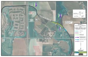
The third of three regional improvement projects identified in the Master Plan of 2006, The Middle Basin Improvements, has gone through a metamorphosis. Originally identified in the Master Plan were two storm drainage channels used to convey local storm flows from the east side of I-25 back to Boxelder Creek and a siphon structure at the crossing of Boxelder Creek and the Larimer and Weld Canal (Canal) as an increased conveyance within Boxelder Creek between CR 54 and CR 52. The improvements were reduced in scope and refined in design. Most of this change of scope for improvements had to do with the eventual size and location of the East Side Detention Facility (ESDF), which greatly reduces the Boxelder 100-year flows where they cross the Larimer and Weld Canal. As a result, these improvements were reduced to a single side-flow spillway structure known as the Larimer-Weld Canal Crossing Structure (LWCCS) at the crossing of Boxelder Creek and the Canal. This structure allows the flood flows from Boxelder Creek to flow across the Canal and minimize the backwater in the Canal that historically spilled into the Cooper Slough Basin on the west side of I-25. The improvements insure that the south bank of the existing Larimer and Weld Canal will not fail when Boxelder Creek floods and overtops the canal. This construction was completed in March 2016.